Let’s take time to break down each of the nine tornadoes that affected northern Ohio last Thursday night.
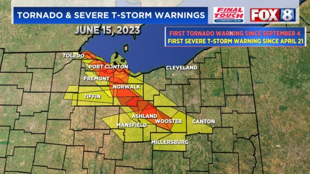
Here are the details of each tornado:
Public Information Statement
National Weather Service Cleveland OH
1121 PM EDT Sat Jun 17 2023

...Summary of tornadoes on June 15, 2023...

.Tornado #1 confirmed near Toledo/Point Place in Lucas County, OH...

Rating:                 EF-2
Peak Wind:              130 mph
Path Length /statute/:  2.0 miles
Path Width /maximum/:   300 yards
Fatalities:             0
Injuries:               0

Start Date:             June 15, 2023
Start Time:             6:06 PM EDT
Start Location:         5 miles north of Downtown Toledo / Lucas County /
Start Lat/Lon:          41.7296/-83.5426

End Date:               June 15, 2023
End Time:               6:10 PM EDT
End Location:           Point Place OH / Lucas County /
End Lat/Lon:            41.7046/-83.4767


Survey Summary:

An NWS Cleveland Storm Survey confirms an EF-2 tornado with a
maximum estimated wind speed of 130 mph occurred in Lucas County on
June 15, 2023. The tornado touched down 1000 feet east of Telegraph
Road along East State Line Road in Toledo. Several tree limbs were
down on power lines with 80 mph winds. The tornado continued to
track southeast, blowing and snapping several power line poles along
North Detroit Avenue with 90 mph winds. The tornado continued
southeast across Interstate 75 and increased wind speeds to 130 mph.
The tornado partially destroyed the second floor of the medical lab
building and blew out windows of a gas station and strip mall on
Suder Avenue. The tornado continued southeast across the more
densely populated Point Place area with mature trees. The tornado
grew in width up to 300 yards producing widespread tree damage,
uprooting trees and numerous broken off tree limbs on houses,
powerlines, and cars. The tornado continued southeast across Cullen
Park, lifting over Maumee Mooring Basin and Maumee River.

NWS Cleveland thanks Lucas County Emergency Management Agency for
their assistance with the storm survey on June 16.

&&


.Tornado #2 confirmed south of Oak Harbor in Ottawa County, OH...

Rating:                 EF2
Estimated Peak Wind:    130 mph
Path Length /statute/:  3.45 miles
Path Width /maximum/:   200 yards
Fatalities:             0
Injuries:               0

Start Date:             06/15/2023
Start Time:             06:49 PM EDT
Start Location:         3 S Oak Harbor / Ottawa County / OH
Start Lat/Lon:          41.4688 / -83.1457

End Date:               06/15/2023
End Time:               06:58 PM EDT
End Location:           3 ESE Oak Harbor / Ottawa County / OH
End Lat/Lon:            41.4863 / -83.0834

Survey Summary:

A tornado touched down about 3 miles south of Oak Harbor in Ottawa
County and tracked east-northeast, damaging five homes. A few of
these residences lost roofs. The tornado also destroyed seven
barns and up to ten cattle fatalities were reported.

NWS Cleveland thanks Ottawa County Emergency Management Agency
for their assistance with the storm survey on June 16.

&&


.Tornado #3 confirmed in Rice Township in Sandusky County, Ohio...

Rating:                 EF1
Estimated Peak Wind:    95 mph
Path Length /statute/:  0.15 miles
Path Width /maximum/:   100 yards
Fatalities:             0
Injuries:               0

Start Date:             06/15/2023
Start Time:             06:57 PM EDT
Start Location:         4 NE Lindsey / Sandusky County / OH
Start Lat/Lon:          41.4494 / -83.1558

End Date:               06/15/2023
End Time:               06:58 PM EDT
End Location:           4 NE Lindsey / Sandusky County / OH
End Lat/Lon:            41.4498 / -83.153

Survey Summary:

A tornado briefly touched down near the intersection of Township
Road 153 and Township Road 146 in Rice Township, OH. The tornado
tracked east-northeast and blew down seven trees and two trees
were blown down onto a home. Another tree was snapped at the base.
The tornado lifted just east of the home.

NWS Cleveland thanks Sandusky County Emergency Management Agency
for their assistance with the storm survey on June 16.

&&


.Tornado #4 confirmed near Vickery in Sandusky County, OH...

Rating:                 EF0
Estimated Peak Wind:    80 mph
Path Length /statute/:  0.33 miles
Path Width /maximum/:   50 yards
Fatalities:             0
Injuries:               0

Start Date:             06/15/2023
Start Time:             07:18 PM EDT
Start Location:         6 WSW Castalia / Sandusky County / OH
Start Lat/Lon:          41.3867 / -82.922

End Date:               06/15/2023
End Time:               07:19 PM EDT
End Location:           5 WSW Castalia / Sandusky County / OH
End Lat/Lon:            41.3859 / -82.9158

Survey Summary:
A tornado briefly touched down along CR 247 partially destroying a metal
roof of outbuilding. Tornado tracked east southeast across Schertz Ditch and
continued into a tree line. Metal roofing was thrown into a field
and shingles from a home were thrown back toward the west.

NWS Cleveland thanks Sandusky County Emergency Management Agency
for their assistance with the storm survey on June 16.

&&


.Tornado #5 confirmed in Bellevue in Sandusky County, Ohio...

Rating:                 EF0
Estimated Peak Wind:    80 mph
Path Length /statute/:  0.93 miles
Path Width /maximum/:   500 yards
Fatalities:             0
Injuries:               0

Start Date:             06/15/2023
Start Time:             07:40 PM EDT
Start Location:         1 NW Bellevue / Sandusky County / OH
Start Lat/Lon:          41.2845 / -82.8514

End Date:               06/15/2023
End Time:               07:42 PM EDT
End Location:           Bellevue / Sandusky County / OH
End Lat/Lon:            41.2719 / -82.8452

Survey Summary:
A tornado began on Parkview Place in northern Bellevue, knocking
over several power poles. It tracked southeast into Robert Peters
Park where several large branches were snapped off the tops of
several trees. It continued south to Kilbourne Street where it
damaged more trees before dissipating. Other damage surveyed
throughout southeast Sandusky County, including Clyde and York
Township, was consistent with straight line wind damage estimated
up to 70 mph.

Thanks goes out to Sandusky County Emergency Management and
Bellevue Police for help with the damage survey.

&&


.Tornado #6 confirmed in Peru Township in Huron County, Ohio...

Rating:                 EF2
Estimated Peak Wind:    115 mph
Path Length /statute/:  9.43 miles
Path Width /maximum/:   1100 yards
Fatalities:             0
Injuries:               0

Start Date:             06/15/2023
Start Time:             07:48 PM EDT
Start Location:         2 S Monroeville / Huron County / OH
Start Lat/Lon:          41.2172 / -82.7036

End Date:               06/15/2023
End Time:               08:04 PM EDT
End Location:           1 WSW North Fairfield / Huron County / OH
End Lat/Lon:            41.1031 / -82.6329

Survey Summary:

An NWS Cleveland Storm Survey confirms an EF-2 tornado with a
maximum estimated wind speed of 115 mph occurred in Huron County
on June 15, 2023. The tornado began a couple miles south of
Monroeville in the vicinity of Standardsburg Road and Hettle
Road, where several trees were snapped along the roadway and
along the West Branch of the Huron River. The tornado continued
south along Hettle Road toward Terry and Peru West Section Line
Roads, where tree damage continued and a couple barns and
outbuildings sustained EF-0 to EF-1 damage. The most significant
damage from this tornado occurred in the vicinity of Snyder Road
and Peru Center Road. Several residences were heavily damaged
from higher end EF-1 to lower end EF-2 tornado wind speeds. A
piece of slate roofing was lifted off a building north of Snyder
Road and impaled a tree to the southeast. An outbuilding was
completely destroyed and material from this structure was lofted
a quarter of a mile southeast into a residence before eventually
settling into a tree line. In this area, about 10 buildings total
sustained damage. One residence was shifted off its foundation.
The tornado continued south across Peru Center Road toward
Townline Road 131 and State Route 61, where additional tree
damage and minor outbuilding damage was noted. As the tornado
reached Hanville Corners Road and Townline Road 113, several
outbuildings and silos were heavily damaged with twisted debris
lofted in various directions. A resident of this area noted that
there was strong southerly inflow into the storm, causing some
light damage before the main tornado hit from the north. The
tornado continued southeast toward State Route 162 and Ridge
Road, where this tornado heavily damaged a barn before cycling
out, west of the village of North Fairfield. To the west of this
tornado track, damage from strong straight-line winds was noted,
consisting of estimated wind speeds of 80 mph for portions of
western Peru Township and northern portions of Greenfield
Township.

NWS Cleveland thanks Huron County Emergency Management Agency for
their assistance with the storm surveying on June 16.

&&


.Tornado #7 confirmed in North Fairfield in Huron County, Ohio...

Rating:                 EF1
Estimated Peak Wind:    110 mph
Path Length /statute/:  9.92 miles
Path Width /maximum/:   1100 yards
Fatalities:             0
Injuries:               0

Start Date:             06/15/2023
Start Time:             07:59 PM EDT
Start Location:         2 N North Fairfield / Huron County / OH
Start Lat/Lon:          41.1406 / -82.6025

End Date:               06/15/2023
End Time:               08:17 PM EDT
End Location:           1 WSW Greenwich / Huron County / OH
End Lat/Lon:            41.0277 / -82.5317

Survey Summary:

An NWS Cleveland Storm Survey confirms an EF-1 tornado with a
maximum wind speed of 110 mph occurred in Huron County on June
15, 2023. This tornado formed as a supercell thunderstorm cycled
across central Huron County after the dissipation of another
tornado. This tornado started in the vicinity of New State Road
and Townline Road 131, downing a deteriorating barn.  As the
tornado continued south toward the village of North Fairfield,
the tornado increased in intensity, lifting a large portion of a
roof off an outbuilding and downing several trees on Hanville
Corners Road. A power pole was separated from power lines with
additional tree damage.  The tornado entered North Fairfield
causing widespread tree and power line damage throughout the
village. Some roofing material was lifted off residences and some
trees fell onto homes. A large sign was ripped off the facade of
a building and several light and power poles were leaning along
Main Street/State Route 162. Damage in the village reflected an
EF-0 to EF-1 tornado but was the widest swath of damage in the
path of this tornado. The tornado continued southeast across Penn
Road toward Old State Road and Olive Road, where a large area of
snapped and shredded trees fell and additional damage occurred to
several barns and outbuildings. The maximum intensity of damage
occurred near the intersection of Old State Road and Townline
Road 12. Several large trees were snapped and a mobile home was
heavily damaged. Just east of this intersection, three power
poles were snapped at the base. As the storm continued southeast
toward Boughtonville Road, several silos were heavily damaged. In
the vicinity of Edwards Road and Boughtonville Road, several
roofs were displaced off outbuildings and the second floor of a
residence was heavily damaged. The tornado continued toward
Greenwich Milan Townline Road, where a large path of trees were
snapped. The tornado began to cycle down west of the Village of
Greenwich, where some minor tree damage and a leaning power pole
was noted off US Route 224 and Greenwich Milan Townline Road.
Much like the first tornado in the county, there was a large area
of strong straight-line wind damage west of this damage path,
consisting of estimated wind speeds of 80 mph for portions of
Fairfield and Ripley Townships.

NWS Cleveland thanks Huron County Emergency Management Agency and
the Fairfield Volunteer Fire Department for  their assistance
with the storm surveying on June 16.

&&


.Tornado #8 confirmed in Greenwich in Huron County Ohio...

Rating:                 EF1
Estimated Peak Wind:    105 mph
Path Length /statute/:  4.05 miles
Path Width /maximum/:   250 yards
Fatalities:             0
Injuries:               0

Start Date:             06/15/2023
Start Time:             08:18 PM EDT
Start Location:         3 NW Greenwich / Huron County / OH
Start Lat/Lon:          41.0656 / -82.563

End Date:               06/15/2023
End Time:               08:24 PM EDT
End Location:           3 NNE Greenwich / Huron County / OH
End Lat/Lon:            41.0631 / -82.4857

Survey Summary:

An NWS Cleveland Storm Survey confirms an EF-1 tornado with a
maximum wind speed of 105 mph occurred in Huron County on June
15, 2023. This tornado was the final tornado of a series from a
supercell thunderstorm that cycled across Huron County. This
tornado had a deviant west to east track, when compared to the
first two tornadoes. This tornado started in the vicinity of
Townline Road 12 and Edwards Road, where several softwood trees
were snapped. The tornado hit a business causing damage to an
office, several silos, an outbuilding, and some equipment. The
tornado followed Townline Road 12 east to Greenwich Milan
Townline Road, where some additional tree damage was noted along
with a clear path in a field. Some weak EF-0 damage continued
with downed trees along Omega Road before the tornado dissipated
near State Route 13, northeast of Greenwich.

NWS Cleveland thanks Huron County Emergency Management Agency and
the Fairfield Volunteer Fire Department for their assistance with
the storm surveying on June 16.

&&


.Tornado #9 confirmed near Nankin in Ashland County, Ohio...

Rating:                 EF-0
Estimated Peak Wind:    85 mph
Path Length /statute/:  1.2 miles
Path Width /maximum/:   300 yards
Fatalities:             0
Injuries:               0

Start Date:             June 15, 2023
Start Time:             847 PM EDT
Start Location:         1 NNE of Nankin / Ashland County /
Start Lat/Lon:          40.9343/-82.2738

End Date:               June 15, 2023
End Time:               849 PM EDT
End Location:           1 E of Nankin / Ashland County /
End Lat/Lon:            40.9211/82.2578


A tornado touched down between County Road 801 and State Route
58, northeast of Nankin, OH where several trees were uprooted with
branches snapped. The tornado tracked southeast towards Township
Road 713 where one residence had damage to a roof, chicken coop,
and a barn that lost a portion of the roof. Also near Township
Road 713 and Route 302, an outbuilding suffered damage with both a
garage door and walls pushed out with insulation lofted into a field.

NWS Cleveland thanks Ashland County Emergency Management Agency
for their assistance with the storm survey on June 16.

&&

EF Scale: The Enhanced Fujita Scale classifies tornadoes into the
following categories:

EF0...Weak......65 to 85 mph
EF1...Weak......86 to 110 mph
EF2...Strong....111 to 135 mph
EF3...Strong....136 to 165 mph
EF4...Violent...166 to 200 mph
EF5...Violent...>200 mph

NOTE:
The information in this statement is preliminary and subject to
change pending final review of the event and publication in NWS
Storm Data.

$$